Fiona and Rasterio
Data Access for Python Programmers and Future Python Programmers
Sean Gillies @Mapbox
FOSS4G 2014 ∙ Portland ∙ September 10
New Python packages
- Fiona and Rasterio are Python interfaces to OGR and GDAL
- Each are native GeoJSON speakers
- Each embrace the good parts of Python
- Each embrace the command line
A Double Challenge
- Helping experienced Python programmers learn GIS concepts
- Helping GIS experts learn to be better Python programmers
Mapbox Cloudless
We have interesting problems
- Off-the-shelf solutions are scarce
- Trial and error is involved
- We need new software
Software requirements
- Allow rapid prototyping and iteration
- Use dependable algorithms
- Scale out to many computers
Fulfilling requirements
- 1 and 3 argue for open source
- 1 argues for a high-level language with handy multi-dimensional array syntax
- 2 argues for LAPACK (&c) and GDAL
- The fit: Linux, Python, Numpy, Scipy
GDAL Python bindings?
- They've served us long and well
- But they don't fit well with the good parts of Python
- We can do better
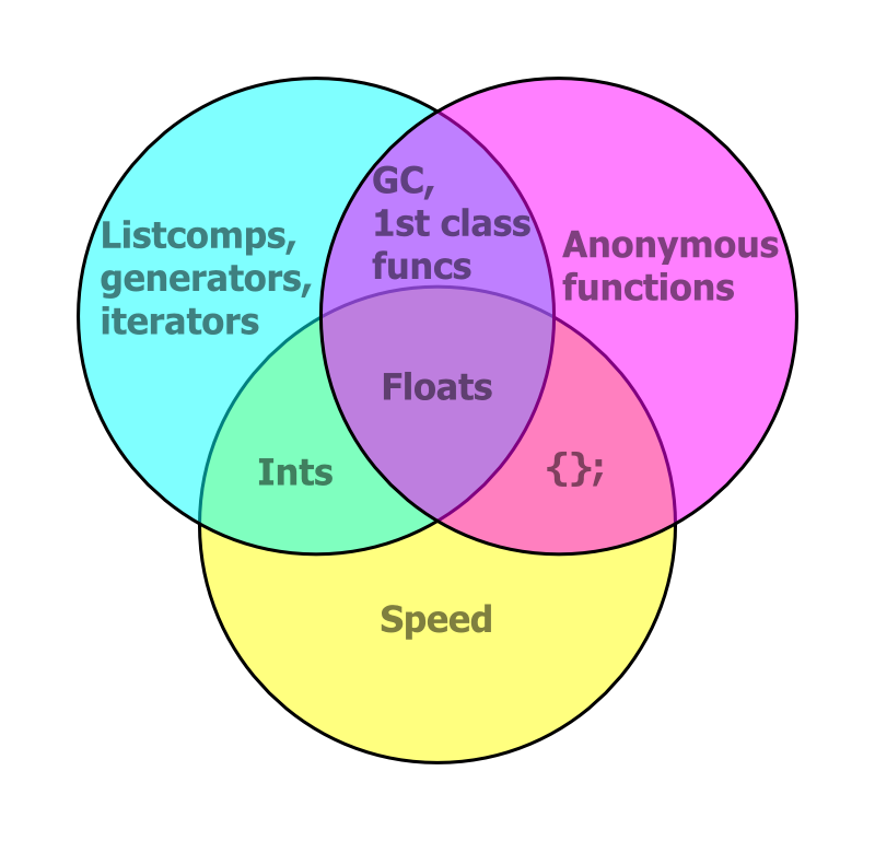
The good parts
OGR Example
from osgeo import ogr

# Create ring
ring = ogr.Geometry(ogr.wkbLinearRing)
ring.AddPoint(1179091.1646903288, 712782.8838459781)
ring.AddPoint(1161053.0218226474, 667456.2684348812)
ring.AddPoint(1214704.933941905, 641092.8288590391)
ring.AddPoint(1228580.428455506, 682719.3123998424)
ring.AddPoint(1218405.0658121984, 721108.1805541387)
ring.AddPoint(1179091.1646903288, 712782.8838459781)

# Create polygon
poly = ogr.Geometry(ogr.wkbPolygon)
poly.AddGeometry(ring)Analogy
# C style
nums = []
for i in range(100):
    nums.append(i)
# Python style
nums = list(range(100))
Not just less code – faster
$ python -m timeit -s "nums=[]" "for i in xrange(1000):" "  nums.append(i)"
10000 loops, best of 3: 76.4 usec per loop
$ python -m timeit -s "nums=list(xrange(1000))"
100000000 loops, best of 3: 0.0108 usec per loop
Literal syntax: {} for geometries
# Create polygon
poly = {
    'type': 'Polygon',
    'coordinates': [[
        (1179091.1646903288, 712782.8838459781),
        (1161053.0218226474, 667456.2684348812),
        (1214704.933941905, 641092.8288590391),
        (1228580.428455506, 682719.3123998424),
        (1218405.0658121984, 721108.1805541387),
        (1179091.1646903288, 712782.8838459781) ]]}
Pay only for what you eat
# This is "dumb" data, no methods.
data = {
    'type': 'Polygon',
    'coordinates': [[
        (1179091.1646903288, 712782.8838459781),
        ...
        (1179091.1646903288, 712782.8838459781) ]]}

# When you need spatial methods, bring in Shapely.
from shapely.geometry import shape
print shape(data).buffer(100.0).area
Winning the Double Challenge
- Python programmers get GIS data access via familiar Python idioms (dicts, iterators, &c.)
- Future Python programmers learn to do things in the fast and effective Python way
Design of Fiona and Rasterio
- A Python package at the top
- Extension modules (using Cython) in the middle
- Fast loops, typed memoryviews, "nogil" blocks
- GDAL shared library on the bottom
Reading raster data
import rasterio

with rasterio.open(path) as src:
    data = src.read()
open()gives you a file-like dataset objectread()gives you a Numpy ndarray- Read windows of data with extended slice-like syntax
Reading vector data
import fiona

with fiona.open(path) as src:
    first = next(src)
open()gives you a file-like iteratornext()gives you the next feature record from the iterator- Records are Python dicts
Writing raster data
kwargs = src.meta

with rasterio.open(path, 'w', **kwargs) as dst:
    dst.write(arr)
- Get keyword args needed to open a dataset for writing from another dataset
write()takes an ndarray- You can also write to windows of a dataset
Writing vector data
kwargs = src.meta

with fiona.open(path, 'w', **kwargs) as dst:
    dst.write(record)
- Get keyword args needed to open a dataset for writing from another dataset
write()takes a feature record dict
Georeferencing
Fiona and Rasterio follow the lead of pyproj
>>> import rasterio
>>> src = rasterio.open('tests/data/RGB.byte.tif')
>>> src.crs
{'units': 'm', 'zone': 18, 'ellps': 'WGS84', 'proj': 'utm', 'no_defs': True}
rasterio.features module
rasterio.features.shapes()yields all the features of an array as GeoJSON-like objectsrasterio.features.rasterize()"burns" GeoJSON-like objects into an array- Dicts, iterators, tuples, ndarrays
- No datasets or layers necessary

{'coordinates': [[(71.0, 6.0), ...]], 'type': 'Polygon'}, ...

rasterio.warp module
rasterio.warp.reproject()maps elements of one array to another, using cartographic projections- No datasets or layers required
- Data created in non-GIS programs can be reprojected for use with GIS programs
In the Beginning...
Was the Command Line
Grep is cool, but
$ gdalinfo tests/data/RGB.byte.tif | grep -c '^Band \d'
3
Command Line Fun
$ rio --help
Usage: rio [OPTIONS] COMMAND [ARGS]...

  Rasterio command line interface.

Options:
  -v, --verbose  Increase verbosity.
  -q, --quiet    Decrease verbosity.
  --help         Show this message and exit.

Commands:
  bounds     Write bounding boxes to stdout as GeoJSON.
  info       Print information about a data file.
  insp       Open a data file and start an interpreter.
  merge      Merge a stack of raster datasets.
  shapes     Write the shapes of features.
  transform  Transform coordinates.
rio info
$ rio info tests/data/RGB.byte.tif --indent 2
{
  "count": 3,
  "crs": "EPSG:32618",
  "dtype": "uint8",
  "driver": "GTiff",
  "bounds": [
    101985.0,
    2611485.0,
    339315.0,
    2826915.0
  ],
  "height": 718,
  "width": 791,
  "nodata": 0.0
}
Single items
$ rio info tests/data/RGB.byte.tif --count
3
$ rio info tests/data/RGB.byte.tif --crs
EPSG:32618
$ rio info tests/data/RGB.byte.tif --bounds
101985.0 2611485.0 339315.0 2826915.0
rio.shapes | geojsonio
$ rio shapes /tests/data/shade.tif --precision 5 \
> | underscore extract features.112 \
> | geojsonio
New Releases
- Fiona 1.2
- Rasterio 0.13
- Shapely 1.4
Thanks
- Mapbox satellite team (Chris, Charlie, Amit, Bruno, Camilla)
- Asger Petersen, Mike Toews, Brendan Ward, Kelsey Jordahl, René Buffat, Jacob Wasserman, Oliver Tonnhofer, Joshua Arnott, Phil Elson, Matt Perry
- And especially Frank Warmerdam and Even Rouault